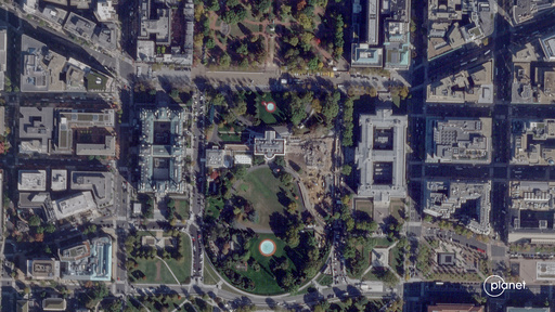
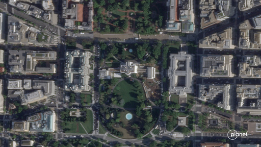
Satellite images show before and after of demolition of White House East Wing

This satellite image from Planet Labs PBC shows the White House in Washington, Sept. 26, 2025, with the East Wing intact before demolition began. (Planet Labs PBC via AP)
This satellite image from Planet Labs PBC shows demolition of the East Wing of the White House in Washington, Thursday, Oct. 23, 2025. (Planet Labs PBC via AP)
Carbonatix Pre-Player Loader

Audio By Carbonatix

WASHINGTON (AP) — New satellite images taken Thursday show the scale of the demolition of the White House East Wing as President Donald Trump moves forward with the construction of a new ballroom at the White House.

See the change in images from Oct. 23 and Sept. 26, 2025 in images from Planet Labs PBC.
 

Trending Videos

Salem News Channel Today

Sponsored Links

Trending Videos

On Air & Up Next

  • InvestTalk with Justin Klein and Luke Guerrero
     
    InvestTalk™ serves as your go-to educational platform to delve into the   >>
     
  • Business on the Edge
    7:00PM - 8:00PM
     
    Money Team 2.0 Business Coach, Margaret Jackson, engages your thoughts in   >>
     
  • Bloomberg Businessweek
    8:00PM - 9:00PM
     
    Get the latest news from the world of business and finance and the interesting   >>
     
  • New Focus on Wealth
    9:00PM - 10:00PM
     
    Each day Rob Black and CFP Chad Burton will filter through the “noise” on Wall   >>
     
  • Radio Yesteryear
    10:00PM - 11:00PM
     
    Tune in for the best of the golden age of radio on “Radio Yesteryear”, as   >>
     

See the Full Program Guide